Outdoors

Sabino Canyon
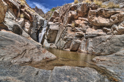
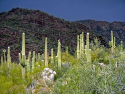
Experience the beauty of one of the most unique Southwestern desert canyons on a Sabino Canyon tram ride. Sabino Canyon is a natural desert oasis located in Tucson’s Coronado National Forest and is home to spectacular desert landscapes and abundant wildlife. During the winter and summer rainy seasons, pools of water form in rocky outcroppings that wind up among hillsides resplendent with palo verde trees, cholla and prickly pear cactus and graceful groves of ocotillo. Sabino Canyon Tours 5900 N. Sabino Canyon Road Information – (520) 749-2861 Reservations – (520) 749-2327

Mt. Lemmon
Mount Lemmon (O’odham: Babad Doʼag) is the highest point in the Santa Catalina Mountains, located in the Coronado National Forest north of Tucson, Arizona, United States. Peak elevation is 9157 ft (2791 m). It receives about 57 inches (1.4 m) of snow annually. Mount Lemmon received itsEnglish name in honor of botanist Sarah Plummer Lemmon, who trekked to the top of the mountain with Native American guides by mule and foot in 1881Tucson’s recreational outlet, Mount Lemmon (Mt. Lemmon) is usually available all year for hiking, camping and day trips. The foothills of the Catalina Mountains north of Tucson, AZ. begins with the roughly hour long journey to the top of the hill known as Mount Lemmon (Mt. Lemmon), Arizona and the village of Summerhaven, Arizona.Summerhaven, the pinnacle, is open and so are all camping and hiking areas. Find out more about the status of Mt. Lemmon and Summerhaven from Mt. Lemmon General Store & Gift Shop or Ski Valley. Yes, that’s right, Mt. Lemmon provides a place to ski in Tucson, Arizona!As the weather cools in the Tucson valley, it also cools at the top of the Santa Catalina mountains by 25-30 degree F. If you plan to travel in the morning, it will be chillier when you get to the top at Summerhaven or the Ski Lift. Bring an extra sweater or jacket in case the temperatures drop.
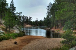
Catalina State Park
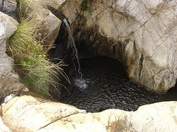
Hiking, horseback riding and bicycling on the trails are popular activities, with eight trails varying in length and difficulty. Leashed dogs are welcome on all trails. All trails are multi-use except Romero Ruin. Free trail guide available at Visitor Center. The Romero Ruin Interpretive Trail (3/4-mi.) meanders through the ruins of a prehistoric Hohokam village site that is over a thousand years old. The mile-long Nature Trail offers beautiful vistas of the Sonoran Desert and Santa Catalina Mountains, with signs explaining the desert ecosystem and its inhabitants. The Romero Canyon Trail (7.2 mi.) and the Sutherland Trail (10.5 mi.) offer longer, more strenuous hikes through beautiful desert terrain and riparian canyons. Both climb to cool natural pools and connect with other Coronado National Forest trails which continue on to Mount Lemmon at the top of the Catalina Mountains. The Canyon Loop Trail (2.3 mi.) is representative of the various habitat types found in the park. The 50-Year Trail (7.8 mi.) is popular with equestrians and mountain-bikers. The Birding Trail (1 mi.) offers hikers a chance to see some of the park’s 170+ species of birds in three different types of habitats. The Bridle Trail (1.4 mi) is the only completely flat trail in the park, connecting the Equestrian Center with the main trail head.

Tucson Mountain Park
 About the park Tucson Mountain Park was established April 1929. The Pima County Parks Commission, with C. B. Brown as its chairman, was established to oversee the park. At approximately 20,000 acres, the park is one of the largest natural resource areas owned and managed by a local government in the U.S. The park has approximately 62 miles of non-motorized shared-use trials. The park’s trails are open to hikers, equestrians, and mountain bikers, and provide a wide range of outstanding experiences, including technical challenges, and breathtaking views. Gates Pass overlook includes interpretive displays and historic structures. Picnicking and wildlife viewing opportunities are located throughout the park.Park Rules
- Tucson Mountain Park is open from dawn to dusk.
- No alcohol is allowed in the park.
- Stay on designated trails.
- Motorized vehicles are prohibited off roads.
- It is illegal to remove or disturb any natural or cultural resources.
- Do not feed wildlife.
- Dogs are not allowed in Tucson Mountain Park.
- Geocaching is not allowed.
- Loitering is not allowed at trailheads or in other areas.
- Trailheads are for park access only.
Recreation Areas There are three picnic areas within the park: Juan Santa Cruz, Ironwood, and Brown Mountain. Amenities available at the picnic areas are tables, ramadas, and grills. Gates Pass Overlook is a popular observation location. It offers an excellent opportunity to view and photograph spectacular sunsets. Also found within the boundaries of TMP are the renowned Arizona-Sonora Desert Museum, Old Tucson Studios, and the Sonoran Arthropod Studies Institute(SASI). Safety Checklist
- Take an ample supply of water with you.
- Wear a wide brimmed hat.
- Apply sunscreen.
- Wear strudy, comfortable walking shoes.
- Know your route.
- Hike with a friend.
- Inform someone where you are going and when you expect to return.
- Know your limitations.
- Carry a cell phone but be aware that reception may not be available in all areas.
- Do not litter – pack it in, pack it out.
- Be aware of cacti and venomous animals.
- Washes and streams can fill up quickly after a rainstorm. Stay away from the banks and do not attempt to walk or drive across washes, streams, or rivers.